Gas station nearby Takuras
Lithuania
Gas station nearby Takuras
Takuras
Fermentų gatvė, 02300, Vilnius, Vilniaus miesto savivaldybė, LT Lithuania
contacts phone
:
+370
Latitude:
54.6271312
, Longitude:
25.1488091
larger map & directions
read more
nearest Gas station
9 m
Takuras
Kirtimų gatvė 33, Vilnius
Gas station
read more
694 m
Lukoil
Kirtimų gatvė 29, Vilnius
Gas station
read more
733 m
Dujų balionų pildymo centras
V. A. Graičiūno gatvė 20A, Vilnius
Gas station
read more
2.407 km
Neste
J. Tiškevičiaus gatvė 19, Trakų Vokė
Gas station
read more
2.532 km
Circle K Vokė
J. Tiškevičiaus gatvė 24, Vilnius
Gas station
read more
2.677 km
Alauša
Vilnius
Gas station
read more
2.68 km
Alauša
Kirtimų gatvė 23, Vilnius
Gas station
read more
2.753 km
EMSI
Savanorių prospektas 225, Vilnius
Gas station
read more
2.794 km
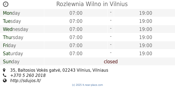
Rozlewnia Wilno
Baltosios Vokės gatvė 35, Vilnius
Gas station
read more
3.524 km
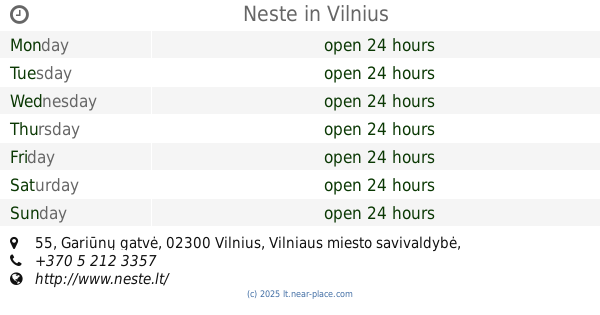
Neste
Gariūnų gatvė 55, Vilnius
Gas station
read more
3.527 km
Rotada
Vilnius
Gas station
read more
3.603 km
Circle K Gariūnai
Gariūnų gatvė 45, Vilnius
Gas station
read more
3.632 km
Saurida
Jankiškių gatvė 43A, Vilnius
Gas station
read more
3.944 km
Alzida
Savanorių prospektas 221, Vilnius
Gas station
read more
4.198 km
Neste
Savanorių prospektas 220a, Vilnius
Gas station
read more
4.719 km
NESTE Savanorių 2
Savanorių prospektas 187, Vilnius
Gas station
read more
4.742 km
Neste
Savanorių prospektas 187D, Vilnius
Gas station
read more
5.616 km
Circle K 1-2-3
Vilnius
Gas station
read more
5.623 km
Circle K 1-2-3 Oslo
Oslo gatvė 12, Vilnius
Gas station
read more
6.112 km
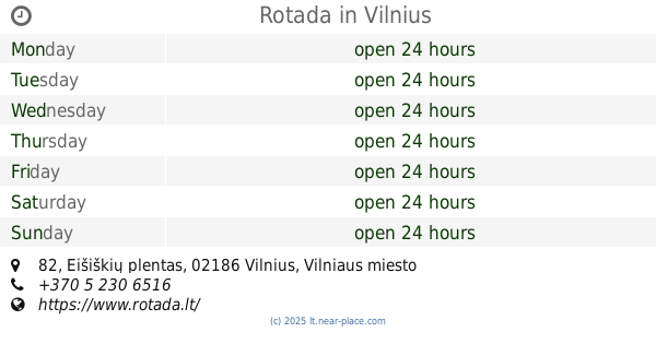
Rotada
Eišiškių plentas 82, Vilnius
Gas station
read more
8.97 km
VIADA
28, Pilaitės prospektas, Vilnius
Gas station
read more
10.307 km
Circle K Talinas
Talino gatvė 2B, 06231, Vilnius
Gas station
read more
13.432 km
Stateta
J. Kazlausko gatvė, Vilnius
Gas station
read more
13.821 km
EMSI
Vilnius
Gas station
read more
13.955 km
CNG
Verkių gatvė 52, Vilnius
Gas station
read more
📑
all categories
Accounting
Administrative area level 1
Administrative area level 2
Airport
Amusement park
Aquarium
Art gallery
Atm
Bakery
Bank
Bar
Beauty salon
Bicycle store
Book store
Bowling alley
Bus station
Cafe
Campground
Car dealer
Car rental
Car repair
Car wash
Casino
Cemetery
Church
City hall
Clothing store
Convenience store
Courthouse
Dentist
Department store
Doctor
Electrician
Electronics store
Embassy
Establishment
Finance
Fire station
Florist
Food
Funeral home
Furniture store
Gas station
General contractor
Grocery or supermarket
Gym
Hair care
Hardware store
Health
Home goods store
Hospital
Insurance agency
Jewelry store
Laundry
Lawyer
Library
Liquor store
Local government office
Locality
Locksmith
Lodging
Meal delivery
Meal takeaway
Mosque
Movie rental
Movie theater
Moving company
Museum
Natural feature
Neighborhood
Night club
Painter
Park
Parking
Pet store
Pharmacy
Physiotherapist
Plumber
Point of interest
Police
Post office
Premise
Real estate agency
Restaurant
Roofing contractor
Route
Rv park, camping
School
Shoe store
Shopping mall
Spa
Stadium
Storage
Store
Subpremise
Supermarket
Synagogue
Train station
Transit station
Travel agency
University
Veterinary care
Zoo
administrative area level 3
↑